
The Importance of Navigational Maps in the Modern World and Business
The trend of card apps is deeply rooted in the market. The geolocation in the application opened the door for new ideas for startups and created enterprises that, in principle, could not exist without this technology.
On the other hand, the possibility of integrating geolocation in a mobile application has brought a new approach to customer service for existing goods and services and a new level of marketing strategies. It has changed the entire consumer interaction workflow.
Some applications are entirely basing on this technology, and even created a new niche based on-location services. It is also used as an additional function to expand the service and make it more advanced.
In this article, we will try to consider the leading players in the navigation industry and show how we made the application, with built-in maps.
Most prominent Players in The Navigation Industry
Most likely, we will no longer be able to use the old map to explore the new world. Cartography is improving, and indeed in some cases, it is being replaced by technology. In the world, several innovative enterprises are working on everything from navigation to analysis. They also create entirely new ways of observing and understanding the world around us.
Let look at companies that are heard by many consumers and business owners, which will reveal the details and pros and cons.
Google Maps
Google Maps was created by Lars and Jens Eilstrup Rasmussen and serves as a web-mapping service for desktops, tablets, and smartphones, developed by Google, launched on February 8, 2005.
The whole world knows about Google Maps today, and this service helps us always find new places. We simply blindly follow this, because it gives us approximately the correct information about where you are in your transport or a public place. Maps provide route information to make sure the user gets to their place conveniently. Also on Maps, there is a function showing how much traffic is on the route, it notifies by color. The visual presentation is always better than textual content.
And take a look at the pros and cons of Google maps:
Pros
Google Maps helps find parking for the user, you save the location of your car and easily find it again
Constant updating, which makes it possible to show the road construction and new designs
Offer the best time to travel
Free Application
Show traffic rules
Show real-time navigation of roads with traffic jams and accidents
Provide detailed information on public transport
Have the ability to show attractions in 3D mode
Street view and pictures of rooms for restaurants, museums and more
Provide cards with private vehicles such as Uber, Lyft, Ola
Redirect you quickly when a faster route is available
Comprehensive, accurate maps in 220 countries and territories
GPS voice navigation for driving, cycling and walking
Transit destinations and maps for more than 15,000 settlements
Compatible with iPhone, iPad and Apple Watch
You can download offline data for cities or parts of cities if you live in an unusually large city, but not for states or countries
PRO Navigation the navigation background depending on the lighting, which is excellent for night driving, as the map will be more noticeable in low light conditions
Maps can search and add a route for a second location on the way to the primary area that you are about to set and have already laid
Cons
To work offline, you must not forget to load the necessary sections of the map in the required resolution
Only online navigation
The inability to fully embed Google maps in the application
There is no advance plan for passengers, that is, it is impossible to plan a trip based on a suburban strip
Not always accurate traffic information, depending on the country
Sometimes takes too long to load
Maps saved offline can easily be erased through automatic updates
Apple Maps
Apple Maps is Apple's mapping service for iOS and macOS. The Maps application for iOS 6 announced on June 29, 2012, at WWDC 2012. It replaced Google Maps, which were previously part of the iOS operating system. Apple representatives said that they used data from TomTom, AutoNavi, and other partners' navigation systems.
Like other representatives, Apple Map also has its pros and cons:
Pros
Internal maps of selected places, namely maps of the location of individual shopping centers and airports around the world, displaying full layouts of each area with icons for restaurants, elevators, bathrooms, shops, etc
A lane guide ensures that users never miss a sudden turn or exit
Color-highlighted areas are color-coded with unique icons, such as a knife and fork for a diner, so that the user can quickly determine the type of location
Adding speed limits for most roads
A platform of augmented reality creates a 3D-rendering of the map, allowing the user to fly over the territory, simulating the feeling of the real presence in the picture.
Apple Maps integrates with other iOS features and devices, such as Siri and Apple Watch
Clicking on a landmark brings up a map with a photo, routes, Yelp reviews and a link to Wikipedia
If the user approaches a part of the map far enough from the current location, Apple Maps will display the local weather elsewhere in the lower right corner
Cons
Apple Maps will display a slowdown in traffic, but the application focuses so much on the user's current location, making it difficult to view future issues
Apple Maps does not warn the user about high-speed traps, obstacles on the road or other road conditions
Apple Maps does not allow a user to download maps for offline use
Apple Maps may be less intuitive concerning any road closures associated with construction while directing the user to impossible travel
OpenStreetMap
OpenStreetMap is an open-source service. Data is created and entered by community members. It thundered through the media as an excellent version of "crisis mapping," In 2010, after the earthquake in Haiti, thousands of users took up the current map of the region, taking into account the changed terrain and drawing points where victims can get help.
The main goal of the OSM mappers community is not to draw a map as creating a database on its basis and filling points with information. Therefore, based on OSM, you can create many new maps: cycling routes, maps of resorts with attractions, etc.
Let's take a closer look at the OSM:
Pros
Complete and genuinely free to use.
The ability to freely edit data
OSM often contains more precious data than other open map sources, for example, someone can digitize all the barriers that a cyclist may encounter when traveling around the city
Cons
Data quality is not clear. Because OSM relies on volunteers located around the world, the quality and consistency of data are random.
Very few, if any, metadata are associated with OSM layers. Inaccuracies in public transport.
At the US national level, the road network is relatively accurate, but most other OSM layers are not. And at the same time, someone could digitize every tree in the parks of your city.
Here
The Nokia-based geolocation platform now belongs to Audi AG, BMW Group, Daimler AG, Intel, Navinfo, NVIDIA, Pioneer, Bosh, Continental. For drivers and logistics services, HERE may be the right solution. HERE maps are in cars from Audi, BMW, Daimler. Yes, and the automakers bought Here as a base for working on autopilot systems, which resulted in the HD Live Map project.
But here have its nuances in work, let's look:
Pros
HERE maps allow users to download maps from more than 200 countries
Interactive 3D maps for shopping centers and airports have created for 70 countries of the world
With HERE, you can navigate to shop, eat, etc.
SD card support
HERE has built-in voice guidance, and it can use even offline
HERE makes it possible to save maps to devices and autonomously use at any time
For large buildings, an icon can open a three-dimensional view of the floor plan with the designation of local services, shops, transport, etc.
The companion app navigates from the Samsung Gear S3 smartwatch. It has step-by-step instructions at intersections and a scalable map using a rotating panel.
It includes routing and timetables for public transport such as trains, ferries, buses, etc. Routes and timetables for many cities. Routes are superimposing on real maps, spatially correct, against typical simplified schemes of public transport networks
HERE has an autonomous navigation application that allows you to create ways for transit and pathways for walking offline
Cons
GPS location is inaccurate
Downloadable maps are enormous and require a lot of space on the device. But there is also the ability to store cards on external SD memory
Does not provide lane guidance
Our Experience in Creating a Mobile App Using Navigation Maps
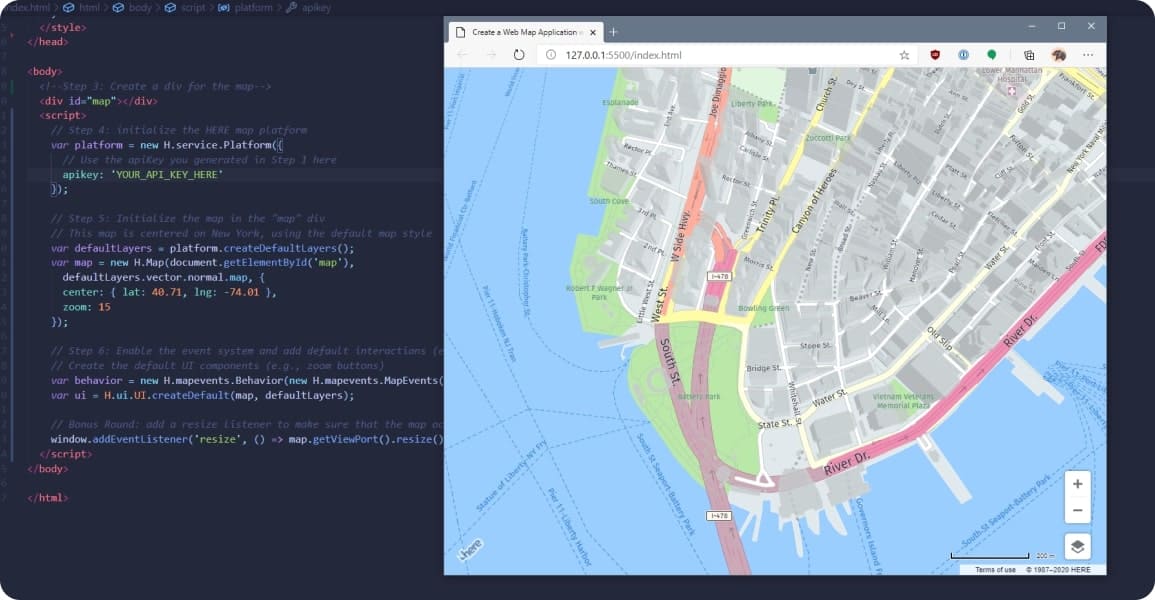
Most recently, we worked on creating a mobile application for a startup. The main task of our team was not only its creation but also the integration of the developed interface with Here Technologies and payment systems in real-time.
The mobile application was created and intended to create and use tours with access to audio, video, and text accompaniment. The critical point was that it was suitable for regular users and professional travelers who can independently create and sell tours in the application. To create a claim, it should embed maps that would directly satisfy all their requests.
The decision has hesitated between choosing Google Maps and Here, and let's see why? Why did the choice fall on Here Maps, and what advantages did this give for the application?
Hold up, and we know what you're thinking about: why can't I just use Google for that?
Well, to some extent, you are right. But Here Maps provides a combination of different types of transport using even sea and horse riding and also works offline with voice support. Nevertheless, such options seem more suitable for the tourist and will allow you to create fantastic guides.
And, in the end, another essential point in the work and embedding.
Just know, you can integrate with Google Maps, fully integrate your business with Google Maps, but you cannot embed it into your app, this option is completely closed. And imagine how convenient it will be for you to open your application, go into Google Maps, and return every time you need to use your route, is it convenient? Honestly, no, and it takes a lot of time, and as a consequence, your business's money.
And otherwise, if you use the Here Technology, then there is the opportunity to make sure extensions and not just integrate with Here. You can optionally embed maps and manage routing in your application. Here in its arsenal has a software development kit specially made for Android, iOS, and the Web. And when you open your app, you no longer need to switch to others. All the maps and the ability to route are built-in automatically, and you can freely use them without spending valuable additional time.
For the project, we have used an extension for the NativeScript mobile application framework called native script-here. Unfortunately, such extension supports only map rendering and does not support HERE SDK's main functionality, which we need for the project - maps routing. So our developers spent a lot of time to expand such NativeScript Extension and support most usable parts of HERE SDK like routing, transport switching, map objects, and others. The results of such work you can take a look at our GitHub fork
Summary
You decide which service to use because many services use the same data sources and provide similar functions. Regarding general navigation, Google Maps seems like the best app on the market today. Thanks to a wealth of information and an intuitive interface, you can find everything you want.
If you are looking for navigation, especially within the same city or region, there are specialized services that may work better. Weigh in detail the pros and cons and only then decide which option is best for you.
If you choose Amoniac as a software development partner, we will be happy to offer a card provider that best suits your business needs.
SHARE ON SOCIAL MEDIA


